
A new, multi-hued map of the moon finally brings together older and newer maps and data about the moon’s geologic makeup into one consistent and colorful resource.
The U.S. Geological Survey (USGS), working with NASA and the Lunar and Planetary Institute, released the authoritative “Unified Geologic Map of the Moon” on April 20. And it is gorgeous!
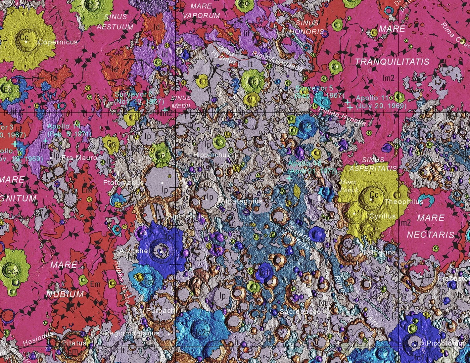
Each color on the moon map represents different topographical features like craters, volcanic units, basins, plains and plateaus.
“The new map will serve as the blueprint of the lunar surface that can be used for future human missions to the moon,” the USGS said in an Instagram video animation (seen below) of the moon chart. “It also provides a useful resource for the international scientific community, educators and the public who are interested in lunar geology.”
View this post on InstagramHave you ever been curious about those bright and dark splotches you see when you look up at a full moon? Well, they tell the 4.5-billion-year-old story of our nearest neighbor in space, and USGS has just released a new authoritative map piecing together the history of the Moon’s surface. The new map will serve as the blueprint of the lunar surface that can be used for future human missions to the moon. It also provides a useful resource for the international scientific community, educators and the public who are interested in lunar geology. For more information about the map, check out the “Unified Geologic Map of the Moon” website: http://ow.ly/OEmp50zgsEG #USGS #science #moon #lunar #geologic
The map was a “decades-long project,” according to Corey Fortezzo, USGS geologist and lead author, in a press release. “It provides vital information for new scientific studies by connecting the exploration of specific sites on the moon with the rest of the lunar surface.”
The best maps from the six Apollo missions to the moon in the 1960s and 1970s were still in paper form. Those Apollo paper charts were re-digitized and combined with newer satellite data. Supplemental data for various regions came from NASA’s Lunar Orbiter Laser Altimeter data and the Terrain Camera from the Japan Aerospace Exploration Agency’s lunar orbiter, SELENE aka Kaguya.
A sample of the map, which is done to a 1:5,000,000-scale, is seen below.
“It was a huge effort for our team to complete this new map and make it seamless,” said Astrogeology Director Justin Hagerty in a short USGS statement. “Much of the historical mapping was performed by various groups and at regional scales. Slightly different methods were used, so that maps of the same feature that had been mapped by different groups would not match.”
Those working on the project had to combine various geologic units and their names and descriptions, along with other inconsistent data between various charts and datasets, to make one go-to model. In doing so, the researchers developed a unified description of the moon’s stratigraphy (rock layers).
To download the full resource, visit Astropedia.
Pretty impressive and beautiful!